Trekking is always a good idea. Going to West Bengal will leave you spellbound as the variety
Sandakphu-Phalut
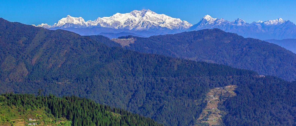
Enjoy the vista of Himalayan snow peaks from Sandakphu, the highest point in West Bengal and accessible from Darjeeling. From Sandakphu, perched at 11,929 ft (3,636 meters), you may catch a glimpse of four of the world’s five highest peaks and their retinue of lesser peaks on a clear day. The 32-km route is a mix of ups and downs but travellers in reasonable good health may complete the trek in five days, including two nights’ stay in Sandakphu. Trekking is open round the year; however, April-May is the time when the rhododendrons bloom while November offers the maximum chance of clear sky days.
Usually, trekkers start from Manebhanjan, pass through Chitray, Meghma, Tonglu (most make a night halt here), Gairibas, Kalipokhari, and Bikeybhanjan to reach Sandakphu. The last stretch includes a steep uphill ascent. In many places, the trek route verges on the motorable road and shares the India-Nepal border. If you are not headed for Phalut, then you may return via Srikhola and Rimbik (most make a night halt here), from where you will get bus/taxi to reach Manebhanjan and Darjeeling.
Phalut (11,811 ft) is 21km away from Sandakphu and the trail is relatively more difficult. The return from Phalut is via Rammam, from where the trail descends to Srikhola.
Trekkers’ huts and private lodges offer basic accommodation in places such as Chitrey, Meghma, Tonglu, Kalipokhri, and Gorkhey; trekker’s huts available at Sandakphu and Phalut. Although advance booking is recommended, it may prove to be difficult owing to poor telephone connectivity. Therefore, you may go through a government registered travel agency for the bookings as well as for arrangements of porters, should you require one.
Note: Do not forget to get the Forest Entry Permit from the Forest Office soon after Manebhanjan; the permit is necessary to pass through the Singalila National Park (the entry point is about a km away from Tumling).
Rangaroon
About 20km from Darjeeling, Rangaroon is a tiny hamlet that perfectly fits the bill if you are looking for a place with friendly trails or a wee bit challenging treks. It is located in the foothills of the Tiger Hill, the place where people rush to see the sun rise over the Himalayan peaks. Go walking through the lush green tea gardens and the village and enjoy a turn of the balmy climate. The village also offers a panoramic view of Darjeeling town standing beneath Mt Kachendzonga. You may go trekking up to the top of Tiger Hill or hike down to the river bed. It is the ‘turning of the river’ Rungdong that gives the place its name. Homestays available.
Buxa Fort
Perched at 2,844 feet, near the India-Bhutan border in Alipurduar district of West Bengal, the Buxa Fort was probably built to protect this stretch of the Silk Route (connecting Tibet with India through Bhtuan). Later, captured by the British, it was rebuilt as a fortified prison that saw many Indian freedom fighters locked up here, including Netaji Subhas Chandra Bose. Today, it stands forlorn at the end of a four-km long uphill and forested trek route. Serious trekkers can also make a day’s trip to Lepchakha. Homestays available at Buxa Sadar Bazaar, about a km ahead of the Fort. Winter is the best time to visit. The Buxa Fort trek starts from Santrabari, about 40km by road from Alipurduar town, the most convenient transport hub.
Ajodhya Pahar
Tucked inside Purulia district of West Bengal, this hill range is part of the Chhota Nagpur Plateau. Although a motorable road exists to the top of Ajodhya Pahar (‘pahar’ meaning hill), the area is often used as training camps for aspiring mountaineers. Usually, trekkers begin the uphill trek from Sirkabad on the eastern edge and descend to Baghmundi on the western edge. There are several waterfalls and tribal hamlets en route. Both points well linked to Purulia town. Matha is also a popular camping ground for holding rock climbing courses and nature camps. Budget accommodation available on top of hill; camping is possible but consult the local forest department (Tel: 03252-222329; dfo_puruliadivision@ yahoo.in) for movement of animals. Some caution is necessary while trekking as it is part of an elephant corridor and one has to cross stretches through dense forest.
Digha

Although coastal trekking is yet to take off in West Bengal, enthusiasts follow a route from Chandipur (in neighbouring Odisha) to the state’s most popular seaside resort, Digha. Most of the trek route lies through Odisha. As the route lies through lonely beach areas, it is best to trek in a group or join one making the trip. Several river crossings are required along the route. Check with local fisher-folk and villagers for information regarding tides. Fishermen usually ferry trekkers in their boats for a small payment. Carry camping gear, provisions, including drinking water, and medicines. Most start the trek early morning from the Chandipur beach, with a night halt each at Kasafal, Dagara and Talsari, before reaching Digha. Usually six to seven hours’ of walking is required daily. At Kasafal and Dagara, seek villagers’ help for camping site or a stay at a local home; hotels available at Talsari, on the Odisha-West Bengal border. Winter is the best time. Sun protection gear and proper shoes must.
trekking
Adventure Holidays in India
India


