The Route: Lamayuru-Wanla-Hinju-Sumdha Chenmo Sumdha Chun-Stakspi La-Alchi I am a Ladakhi. As a young
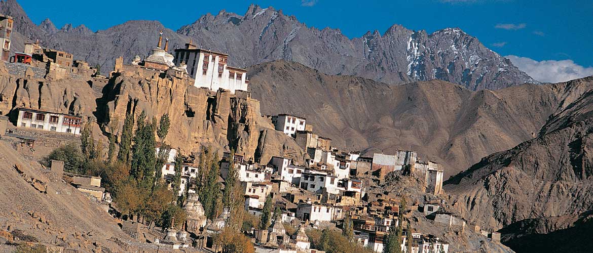
Lamayuru has a camping ground below the awesome escarpment on which perch the huge 11th century monastery and its guest house. There are several guest houses and restaurants in Lamayuru. The yellow loess formations around Lamayuru are most impressive and part of the route takes you past them. At the other end of the trek lies the 11th century temple complex of Alchi. Do spend time here to enjoy the magnificent frescoes.
DAY ONE
DAY ONE LAMAYURU-PRITIKINGI LA-WANLA
TIME 4-5 HOURS
LEVEL EASY

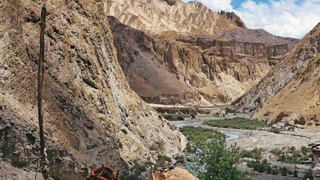
This is a short but hot march. Better to do it early or later in the day. From Lamayuru (11,319 ft), the path goes down to the stream, then turns southeast up a side valley at the chortens and prayer flags. The track then winds its way up through a barren gorge of yellow loess clay, to the Pritikingi La (11,503 ft) pass. Descend steeply eastwards into the Shillakang stream, then turn downstream past Shilla Village and a 30-min walk will bring you to the big village of Wanla (10,500 ft). There is a guest house and a few tea-stalls here. Explore the Wanla Gompa, which is supposed to date from the Alchi period.
DAY TWO
WANLA-HINJU
TIME 5-6 HOURS
LEVEL EASY
Follow the jeep track upstream (hot and dusty) for 2 hrs towards Panji La Pass, where the trail splits. The right path goes south to Padum (Zanskar) up the Wanla River. The left track to Panji La (11,154 ft) Pass leaves the Wanla River and goes high above the village and then descends to join the Ripchar stream after 30 mins. Another hour’s walk brings you to Hinju (12,303 ft). There are several campsites beyond the village, near pullus. These are camping grounds where water is available.
Down Yapola Nallah from Panji La is a route that goes south to Photaksar and thence to Padum.
DAY THREE
HINJU-KONGSKE LA-SUMDHA CHENMO
TIME 4-5 HOURS
LEVEL MEDIUM
It’s a relatively easy climb for 2 hrs above Hinju through several summer pastures. At the shepherds’ shelters, the path leaves the stream and climbs steeply for another couple of hours. The views from the Kongske La (16,076 ft) top are worth it. Looking east-south-east behind a subsidiary mountain range can be seen the attractive peaks (around 19,300 ft) of Alam and Palam. To the south are the peaks of Zanskar, to the west the peaks above Suru and Batalik near Kargil, and north, over Khaltse, the Nubra-Shayok peaks. The descent from the pass is gentle for about 15 mins over snow and ice (if early in the season), then steep down along the Sumdha Chu to the pullus for another 2 hrs. The camp at Sumdha Chenmo (12,795 ft) is just below the vast grazing ground amidst hundreds of yaks, sheep and goats. Be careful of the ferocious sheep dogs that accompany their masters. It is possible to follow the Sumdha Chu to its confluence with the Zanskar River and then get out at Nimmu on the Srinagar-Leh Highway.
DAY FOUR
SUMDHA CHENMO-SUMDHA CHUN
TIME 5-6 HOURS
LEVEL EASY
The trail, moving south-east, crosses many grazing areas and streams. If water levels are low, stay along the river; if high, traverse the southern cliffs for about 90 mins. The path divides 45 mins after leaving Sumdha Chenmo at a bridge. The right path goes to Chilling towards the Zanskar River, and the left path goes into the gorge. Don’t cross the bridge but follow the stream as it flows down. Stay on the main trail that involves four river crossings. Then after about 3½ hrs, towards the left, will be Sumdha Chun (12,631 ft). Between two large boulders turn up into the side valley, towards the north-east, at a large willow growing up against a sheer rock face. The main path continues down to the Nimmu Road. It is another hour’s walk up to Sumdha Chun, which has a beautiful gompa, numerous metal workers, who had originally come from Nepal 200 years ago, and a few small campsites.
DAY FIVE
SUMDHA CHUN-STAKSPI LA-ALCHI
TIME 7 HOURS
LEVEL TOUGH
The climb to the Stakspi La pass is steep and difficult. It can take 4 hrs or more to ascend the scree-laden path. Climb up the valley north-east of the village along a small tributary, to a campsite and pullu — the last place to get water before the pass. Follow the stream gully to the head of the valley. From here, the preferred direct route goes left or right of the crags to a rock band, traverses left below the band and crosses the shoulder to the top.
The route is tough, with the last section over rocky ground only marked by cairns. The reward is the wonderful view from the top of Stakspi La (16,240 ft). The descent to the north is sharp over rocky terrain towards the central spur, then crossing the river twice to the grazing grounds and pullu.
It’s another 3 hrs to Alchi, so consider camping here if tired. Otherwise, carry on to the many guest houses and restaurants at Alchi (10,335 ft).
Time 5-6 days
Level Moderate to Tough
Ideal Season Mid-Jun to late Sep
Location West of Leh, moving west to east
GETTING THERE AND OUT
FROM Leh to Lamayuru on the Leh-Srinagar Highway, it’s 125 km/ 6 hrs by taxi (₹2,500). Or catch the daily Leh- Srinagar (5 am) or Leh-Kargil (5.30 am) bus (₹100-200) for Lamayuru. You can even negotiate a ride on the many trucks that run between Leh and Kargil (₹100-200 is reasonable). RETURN Get picked up at Alchi, take a taxi (return fare ₹1,500) or a bus (₹32) to Leh (67 km/ 2-2½ hrs)
Lamayuru
Alchi
Lamayuru Monastery


