Carved out of the hilly areas of Uttar Pradesh in 2000, Uttarakhand offers a little something for
Day 1-2
Route: Delhi-Nainital
Distance: 298 km
Time: 7 hours
It is best to drive out of Delhi early in the morning, say by 6.00 am, to avoid the terrible traffic on the outskirts of the city. Head towards Ghaziabad via Nizamuddin Bridge, then follow directions until you hit the NH24 and stay on it until you reach Rudrapur. Halt at one of the roadside dhabas or restaurants around here for a quick, but filling breakfast before turning onto the NH87 for Nainital. The road snakes past green mountains and valleys, venerable deodar trees and snow-covered slopes. Stop at one of the tiny roadside eateries for snacks; stalls offering a few refreshments can be found often enough in the hills, but proper dhabas are hard to come by.
Soul City
Like many of India’s classic hill stations, Nainital has been taken over by tourists, traffic and commercialisation, and yet it manages to take your breath away at the odd moment. It is still possible to track down the soul of the place, especially in off-season spring or autumn, in its emerald lake, lovely old houses and its rich bounty of flowers. Take a walk along quaint pine trails in the neighbouring woods or stroll through the lanes away from standard tourist spots, to discover the old charm the area possessed, which is what drew Colonisers and locals alike to settle here. Today the town has become a honeymooner’s haven, where visitors can find everything from Gujarati thalis to cable cars and boat rides. The ever-present snow-capped Kumaon hills in the distance add to the town’s scenic beauty.
Spend a day here, exploring the less touristy sights of the city or just lounging in your hotel room. Choose to stay high up at Ayarpatta, where you can go for long walks in the forests as you slowly acclimatise to the mountains.

Things to See & Do
Naini Lake is the cheerful yet serene centre of this hill town. Walking around it in the crisp autumn or spring sun is a pleasure. Boating and yachting are popular activities. Visit the popular Naina Devi Temple on its north end. A promenade goes around the entire lake; there are benches to sit on and gaze at the water, while enjoying the breeze. Several shops line the edge of the promenade; here you can buy items such as shawls, honey and fruit juices. The Flats (locally called maidan) area level area near the temple. There is a band stand, a fountain, a skating rink and several bazaars here. The Boat House Club on the lake, dating back to the mid-19th century, is a must-see.
The Raj Bhavan (1897-99), with gardens spread over 220 acres and over-flowing with deodars, was the summer residence of the governor of the United Provinces. It is now the official residence of the Uttarakhand Governor. There is also an 18-hole golf course, open to the public for a fee.
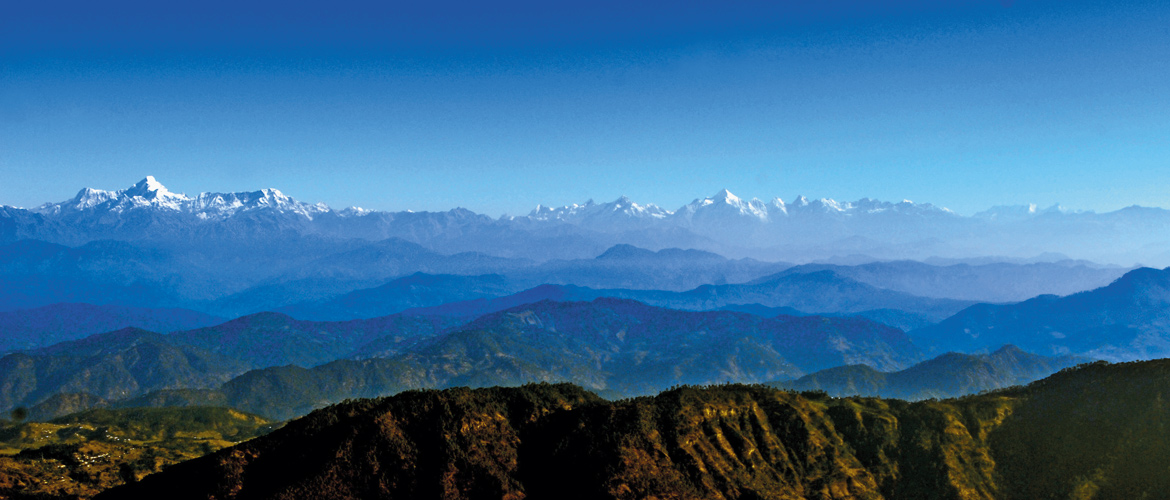
The Tiffin Top Peak (7,520 ft) on Ayarpatta Hill, reached via a winding rugged road, commands a fantastic view of the Himalayas. Also on Ayarpatta Hillis Gurney House, the former residence of Jim Corbett, hunter, conservationist, writer and naturalist. However, it is a private property; entrance is at the discretion of the owner.
Perched on the Ayarpatta slopes, Aurobindo Ashram hosts regular retreats, study groups as well as kid’s camps at nominal fees. Also on offer are discourses on varied spiritual and theological subjects.
The highlight of the Observatory, situated on Manora Peak (6,401 ft), at the Aryabhatta Research Institute of Observational Sciences is its 7.00-9.00 pm slot, when the moon, stars and other celestial bodies can be viewed through one of the four high-power telescopes. Call the institute (Tel: 05942-233727, 233734-35) for permission to visit.
The Nainital High Altitude Animals Zoo has some rare high-altitude species like the Siberian tiger, steppe eagle and the Himalayan black bear. The Eco Park with its cave gardens is a great place to introduce children to a natural ecosphere. An old favourite of holidaymakers, Snow View (7,448 ft), atop Sher-ka-Danda Hill, is reached by a ropeway. There’s also a bumper car ride for kids and fantastic views of the Himalayas. The urban legend is that you can see the Great Wall of China from China Peak. Don’t go believing that. But China Peak (8,579 ft) does have great views. The peak gets its other moniker from a sadhu by the name of Cheena who, they say, once lived here.
There is a good walking trail along the McDonald’s Circular Road. If you stay reasonably quiet, your chances of spotting the shy barking deer are reasonably good. The walk from Tiffin Top to Land’s End (6,949 ft) offers fabulous views of the Khurpatal. Ghurals (wild goats) abound on these steep, barren slopes. From Land’s End to the Stables is another great walk, ending near Bara Patthar, where you can hire horses or climb rocks in season.
Shopping
The Mall, renamed Govind Ballabh Pant Marg, is the touristy hangout where most holidaymakers congregate to stroll, eat, shop and indulge in videogames or billiards. Vehicles are not allowed here in the evenings, especially in summer. The Tibetan Market at The Flats has an assortment of woollies, clothes, toys, candles and other bric-a-brac. Check out the Panchachuli Store for hand-woven stoles and shawls, andthe Fruitage outlet for rhododendron squash, fresh fruit jams, chutneys and the like. The Bara Bazaar caters more to the needs of the locals, and has the standard shops. Check out Gupta Departmental Store and 4 Season Shop for a good selection of candles. You will also find cane sticks as well as wood-craft here.
Day 3-4
Route: Nainital-Binsar
Distance: 98 km
Time: 3.5 hours
The real climb uphill begins on the drive from Nainital to Binsar. A slowly winding road takes you past stunning views; brooks, valleys and deodars give way to oak and pine forests.
Almora itself, however, is a pretty uninspiring stop. The town, once the capital of Kumaon’s Chand dynasty, is today the second largest town in Kumaon, important because it is the base for excursions to Binsar, Kausani and Jageshwar.
Things to See & Do
Almora’s busy markets and sights along the Mall Road are easily discovered on foot. But you’ll need a car for quite a few sights located just outside Almora. Look at old letters at the Gobind Ballabh Pant Public Museum. Head towards the northern end of the Mall, past the chai shops and hair dressers, to the Clock Tower that is actually an old Methodist Church, which was built in 1897.
Walk up to the 200-year-old Lala Bazaar, situated just above the Mall. In the middle of this bustling bazaar lies the ancient Nanda Devi Temple built by the Chand Rajas. Every September, Almora comes alive as thousands flock to this temple for the Nanda Devi Mela, which lasts for five days. Tagore Bhawan in the cantonment area is a Colonial bungalow located on a hilltop that affords some great views of the area.
Bright End Corner, 2.5 km outside Almora on the road back to Sualbari, is the place to view dramatic sunsets and Himalayan peaks. About 5 km further down from Tamra Nagri, the Kasar Devi Temple is situated at a height of 5,741 ft. The painted Rock Shelter of Lakhudiar is close by and dates back to the Stone Age. The walls and ceilings inside have paintings of human beings, animals and trees in red, black and white.

One of the most popular deities in Kumaon is Gollu Devta, once a Chand King, now the god of justice. The most famous of his temples is at Chitai, half an hour from Almora down the road to Pithoragarh. A few kilometres before this lies the Prane Gollu, an atmospheric little temple. Across the Kosi river from Almora, in a cleft of purple hills, is Katarmal (15 km), where you will find the 900-year-old Bara Aditya Temple, a mossy cluster almost invisible at a distance against the hillside.
Shopping
Almora is well known for its copper-ware and you’ll find plenty of it here –from little diyas and bangles to pots and pans to carved images of gods and goddesses. The Khadi Village Industries outlet has lovely shawls, kurtas, dress material, woollen jackets and lots more.
After a quick visit to the sites and some shopping, grab some lunch before heading out of the main town area. Stop on the outskirts to take in the spectacular views before heading to Binsar.
Wild Haven
Located at a distance of 30 km from Almora, the Binsar Wildlife Sanctuary is a birdwatcher’s paradise. Covering just 47sq km of heavily-forested slopes, the sanctuary is home to a variety of flora and fauna, including 200 recorded species of resident and migratory birds. Leopards, black Himalayan bears, jackals, red foxes and wild boars are some of the animals you might catch sight of if you’re lucky. The forests also hold three varieties of oak, rhododendron and chir pines. Spend two nights at the sanctuary.
The best way to explore the park is on foot. It is easy to get lost in the sanctuary, so hire guides; they are a mine of information. A standard excursion here is the kilometre-long gentle ascent from the TRH to Zero Point (8,200 ft), the high centre of Jhandidhar which is the main hill of Binsar. The 360-degree views of the sanctuary and snow-capped hills from here are spectacular. On a clear day it is possible to spot the Nanda Devi, Panchachuli and Nampa peaks; don’t forget to ask your guide to point them out to you. Keep a lookout for hornets’ nests; there are several towards the end of the shorter walk. Trekking enthusiasts can tackle the two six-kilometre-longwalks to Ghoralghot and Sanghaghat.

Things to See & Do
The relatively close-up views of the perpetually snow-clad Greater Himalayan mountain range are truly mind-blowing and a big draw at Binsar. The best time to catch the panorama is in March-April or September- October, when the weather is clear. The best views are available from the TRH and Zero Point. Bineshwar Temple, the 16th-century Shiva shrine from which Binsar takes its name, is set in a clearing by the road, 6 km from Ayarpani. The Gananath temple is ensconced in a cave at a spring source, 30 km from Binsar. The mountain view from Maika, another shrine on the climb, is quite pleasing.
Shopping
A co-operative called the Panchachuli Women Weavers (panchachuli.com) works with women from the villages of this region. Shawls made from the yarn drawn from Himalayan nettle are the unique speciality here. These are available at the charming Aipen: The Kumaoni Shop at the sanctuary gate. Jams, honey, pickles and tea are also available here.
Day 5
Route: Binsar-Gwaldam
Distance: 89 km
Time: 4 hours
Leave Binsar early the next morning for Gwaldam. Worth stopping at on the way is Bageshwar. The town is located at the confluence of the Gomti and Sarayu rivers at 3,200 ft. The temple complex here is the main draw. Built in 1602, it houses idols dating from the 7th-16th centuries. The temples are strung with bells, and come alive during the Uttarayani Mela around Makar Sankranti in January every year. Eat lunch here and head to Baijnath, 23 km to the northeast of the town.
The temple complex at Baijnath, along the River Gomti, is beautifully stark. Its 18 shrines were built between the 9th and 12th centuries by the Katyuri kings, legendarily raat ke raat – with workers working only at nights. Most of the stone idols – except in the main shrine, which houses a magnificent Parvati – have been locked away because of thefts. Stop here if time allows, else head straight to Khandar from Bageshwar. Post Khandar the roads are in terrible shape with no eateries along the route. Remember to refuel and stock up on eatables and water wherever possible.
Lost & Found
A popular summer resort during Colonial times, Gwaldam (6,221 ft) still holds remnants of the Raj in well-preserved nooks. This quiet corner of Chamoli has in recent times fallen off the well-trodden path. It is, however, used as a base for treks and hikes, and is en route to the famous high-altitude pastures of Bedni and Ali bugyals. But Gwaldam, itself, also affords the opportunity for you to experience a uniquely composite hill culture, existing as it does on the border between Garhwal and Kumaon. The town is surrounded by pine forests and has several apple orchards, which add to its charm. Spend a night at one of the hotels here.
Things to See & Do
There are three excellent, not-too-challenging walks to be had, all of which begin at Benatoli. As you drive into Benatoli, you will see the Bhim Patthar rock. Legend goes that the Pandava Bhim kicked a rock at Badhangarhi, which fell at this spot with his footprints imprinted on it. From here, a 1-hr/ 2-km-long forested trail uphill leads to the ridge-top Badhangarhi (7,415 ft). Equally revered by both Kumaonis and Garhwalis, the Kali shrine here is full of bells strung by devotees. A 5-min climb from the temple takes you to a vantage point that offers a panoramic view of the mountains to the north and to the south, the vast bowl of Kumaon’s Katyuri Valley.
Other paths lead from Benatoli upto Agyari Mahadev and to the hilltop shrine of Gwaldam Nag, which gives the town its name. The temple is dedicated to the serpent god and also offers lovely views. It’s an easy 45-min walk from the bus stand to the grazing pasture of Dhan Kharak. Or head to Navali Bugyal, just17 km from Gwaldam. This is a vast alpine meadow with fabulous views of both Garhwal and Kumaon.

The Bhotia settlement at Baghtoli dates to the late 1950s. The Bodh Mandir gompa here was built in 1989. You’ll spot its bright yellow roof from a distance. Hidden in a nook in the ridge along a gentle stream, 9 km out of Gwaldam, on the road to Debal, Machhi Tal came up in 1928, when the British bred fish here for personal consumption. This tranquil spot amidst thick forests makes for a lovely picnic spot.
TO READ PART 2 OF THIS STORY, CLICK HERE
Delhi
Drives
Gwaldam


