Hidden valleys or secret Shangrilas concealed in the folds of mountains have long tantalised people living in
As one ascends its narrow mouth along the feisty Langtang Khola, the valley broadens into a massive U, revealing its true splendour. It still has a surreal quality, as footfalls are few compared to more popular parts of Nepal. This could be due to a lack of top-spot peaks, but the lofty pinnacles and hanging glaciers of Langtang Lirung (7,246m), the snowy folds and creases of Gang Chenpo (6,388m) and the wide riverine basin of Langtang Khola seen from the yak trails show that height is but a number.
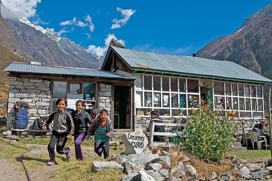
Make base at Tsergo Ri, the lowest peak of Langtang (4,984m), Langshisha Kharak or Charkhori base camp for excursions. The trails in the park ascend steeply from fragrant forests of berberries, juniper and spruce to alpine scrub and grasslands in its higher reaches. En route, teahouses entice travellers with hot butter tea and other yak dairy treats. Leave it for higher ground, where you may meet herds of musk deer and blue sheep — and the Bon Buddhists of the valley.
Adjoining the Langtang Valley lies another distinct valley — a high-altitude wetland reserve that is speckled with beautiful lakes and tarns. Out of the eleven waterbodies spotted and named by the park authorities, Gosainkund and Saraswati Kund are the largest. According to legend, they were formed when Shiva thrust his trident into the ground to create the headwaters of the river Trisuli. The water welling up in the dimples left in the land from its points formed these lovely lakes, which together were designated a Ramsar site in 2007. The challenging pass of Lauribina La is nearby.
The Langtang valley is dominated by the Bon Buddhists, who speak a dialect almost identical to that of Kyirong in Tibet, which is contiguous with this part of Nepal. Tamangs and Bhotias populate the Gosainkund side. Together the two valleys provide a wonderful glimpse of rural mountain life in upland Nepal and the colourful cultural contrasts between Hindu and Buddhist villages. The yak is a universally popular beast, however, crucial to livelihoods.
The information
Bordering Tibet to the north, Langtang National Park is the second largest national park in Nepal, covering an area of 1,700 sq km. The main attraction in the park is the Langtang range in the north and several lakes to the south in the Gosainkund belt.
Langtang’s expansive high meadows provide a summer habitat for numerous ungulate species, such as the musk deer and the Himalayan tahr. The park is also well known for its populations of red panda, Himalayan black bear, snow leopard and ghoral as well as some 373 species of birds.
Getting there
It’s a short 132km by road from Kathmandu to Syabrubesi in the park. However, the road conditions make the bus journey a 10hr ordeal at the best of times. Jeep taxis take less time but charge NPR 5,000–6,000, a worthwhile option if you are in a group.
High-altitude or altitude mountain sickness (AMS) can strike in spite of precautions, so it is best to get your travel agent to arm you with the requisite insurance for a life-saving helicopter rescue, just in case. For more on AMS, look up medex.org.uk or netdoctor.co.uk.
When to go
The best seasons are March to May and October to November.
Fees
A TIMS (Trekkers’ Information Management System) card is a prerequisite for trekking in any area of Nepal and will be organised by your trekking agency for a fee of $20.
The park entrance fee for Langtang is collected at the park post at Dhunche. It is NPR 100 for SAARC nationals and NPR 1,000 for other foreigners.
Trek routes
Depending upon time and inclination, several treks are possible:
A Langtang-and-back circuit takes 8-9 days. Offbeat excursions from here include Langshisha Kharka, which takes 2 days — tents and food are required, especially if you want to explore the glaciers and higher pastures. Other day walks from Kyanjin include a hike to nearby Tsergo Ri (4,984m). The Charkhori basecamp trail skirts high above Langtang Khola, with superb valley and mountain views on the way.
Combine Langtang with the Gosainkund lakes and make it a lovely 14-day trek, entering the park from Syabrubesi and exiting on the Helambu side at Timbu, from where it is a 4hr road journey to Kathmandu.
You can also do Langtang to Helambu via Ganja La (5,120m), a treacherous high pass that requires roping up on some stretches but makes for a rewarding exit on the Helambu side after 12 days. An experienced guide and the right season are essential.
What to see & do
At Kyanjin Gompa in the Langtang Valley and Sing Gompa on the Gosainkunda side, there are two old cheese factories set up with Swiss technical assistance back in the 1950s. The factories themselves are fairly archaic relics of old production techniques. However, it is well worth picking up some of the excellent cheese produced here.
Where to stay & eat
As it is mostly a teahouse trail, you will find food and lodging everywhere. Most people get an agency in Kathmandu to arrange a porter cum guide or a guide only, plus permits, transport, food and lodging in teahouses along the way. All this should cost $700-1,000 for a 14-day trek. Trekking independently is easy on these well-marked trails, but prior trekking experience would help.
Tour operators
Earthbound Expeditions, G.P.O. Box 5801, Thamel, Kathmandu, +977-1-4701051, +977-9841245975, enepaltrekking.com
Equator Expeditions, P.O. Box 8404, Thamel, Kathmandu, [email protected]
Makalu Adventure, P.O. Box 20144, Amrit Marg, Thamel, Kathmandu, +977-9851088335, makaluadventure.com
Langtang Valley
national parks of Nepal
Tibetan beyul
Leave a Reply
You must be logged in to post a comment.


